WhyGo Amsterdam now has maps
 After a certain amount of foot-dragging on my part I’ve finally started adding maps to Amsterdamlogue. Many of the individual attractions posts have maps at the bottom now, and soon they all will, but the best place to start is probably the main Amsterdam map page that is linked in the main menu so it’s one click away from every page.
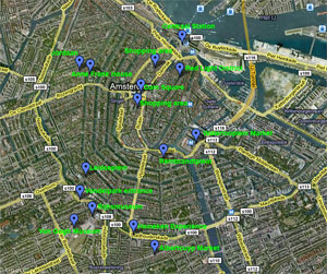
This main city map is just a Google Maps satellite view that I’ve put location pins in for most of the attractions and key neighborhoods you’ll want to familiarize yourself with. I’ve labeled the top map on the page so you can instantly see what each of the blue pins is pointing to, but as a bonus just below you’ll find the actual interactive Google map. You can click on each of the blue pins to find out a bit more information about the place, and also move the map around and zoom in and whatnot.
I’ve also added some handy maps to some of the other posts that deal with multiple things so you can see exactly where they all are at a glance. Again, the map only shows blue pins on these maps, but if you click the pin you’ll see a little pop-up thing that tells you what it is.
Soon everything will have a map, but just to get started you can check out some of the more interesting ones here:
Amsterdam map – main page
Amsterdamlogue’s Top 5 coffee shops
Amsterdam’s Live sex shows